
| HOME |
| EVENTS |
| ISLAND MAP |
| ATTRACTIONS |
| COMMUNITY |
| STATE PARKS |
| FOOD |
| SHOPPING |
| LODGING |
| SERVICES |
| BUILDERS |
| RECREATION |
| FIRE DEP'T |
|
DENSMORE CHURCH |
| WILDLIFE REHAB |
| BOATS |
|
KEEP WILDLIFE AWAY NICELY |
| PHOTO ARCHIVE |
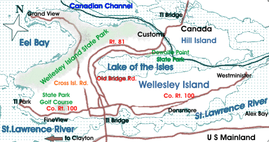
Above is a map
of Wellesley Island showing the main roads,
villages, and State
facilities.
If coming from the American mainland, visitors would get off at exit
51N,
which puts them on the Old Bridge Road, running parallel to Rt. 81.
There is a second exit , exit 52, just before Customs. A right at the
stop
sign when getting off at Exit 51 takes you to Co. Rt. 100, which
runs
the length of the Island.
If coming from Canada, exit 51S is your best bet; that puts you on
Co.
Rt. 100, the main road running east and west for the length of
the
island. No scale is shown, but the island is roughly seven
miles long, and just
under three miles wide. For a map showing how
to find specific places on
the Island, use the Place Finder

VISITING!
Contact us